How to Find Public Land to Hunt
There is more public hunting ground than most people believe, and the tools for finding it are free. The layers that matter, the pressure map nobody draws for you, and how to pick a spot everyone else walks past.
How this is funded: we earn a commission if you buy through our links, at no extra cost to you. It never changes which product we recommend, and we’ll tell you plainly when we’d skip one. Full disclosure.
Start with your state wildlife agency’s own public-land map, add the federal layers, and do the first pass from a screen rather than a truck. The tools that matter are free, and the paid app is a year-two purchase, not a year-one one. The hard part of public-land hunting is not finding land — there is far more of it than most new hunters believe. It is finding the parts of it that other hunters walk past.
Scale first, because it is motivating: Minnesota by itself publishes more than 1,500 wildlife management areas covering 1.39 million acres open to hunters. That is one state’s system, sitting on top of national forests, Bureau of Land Management ground, Corps of Engineers land and refuges that permit hunting. Meanwhile the federal participation data puts hunters at 14.4 million Americans aged 16 and over, about 6 percent of that population. There is more ground than there are people to hunt it; the pressure is just badly distributed.
The free sources, in the order to check them
- Your state wildlife agency.Every state publishes a searchable map or list of its wildlife management areas, public hunting areas or state game lands, with boundaries and area-specific rules. This is the authoritative source for that ground — more so than any app — and it is free.
- National forests. Hunting is permitted on national forest land under state law, and the Forest Service publishes visitor maps and motor vehicle use maps per forest. Its own guidance is that state rules apply and that you should check for area restrictions before you go.
- BLM land, if you are west of the Mississippi. Vast, under-hunted in places, and mapped publicly. Access is often the constraint rather than permission.
- Army Corps of Engineers ground. The land around federal reservoirs is frequently open to hunting and is routinely overlooked, because people do not think of a lake as hunting land.
- National wildlife refuges.Many permit hunting, often with their own permit, season dates and shot-type rules layered on top of the state’s.
- Walk-in access programmes. Several midwestern and western states pay private landowners to open ground to public hunting. It is free to hunt, usually foot-access only, and commonly the least pressured ground in the state.
Check enrolment and boundaries every year on the last two. Refuge rules and walk-in enrolments change annually, and last season’s map is not evidence of this season’s access.
The four map layers that actually decide a spot
Once you have a parcel, the work is reading it. Four layers, in this order, will tell you more than a day of driving around.
- Satellite imagery, for cover. Look for the edges: where timber meets a field, where mature woods become a cut, where a grass strip runs between two blocks of cover. Deer and birds live on edges, and edges are visible from space for free.
- Topography, for terrain funnels.Saddles between two high points, benches on a hillside, the inside bend of a creek — these concentrate movement, and they are the reason a contour map beats an aerial photo for whitetails in hill country.
- Access points, for pressure. Mark every parking area, gate, boat ramp and road pull-off on the parcel. This is the layer nobody draws, and it is the one that decides your season. Hunting pressure radiates outward from parking, and it drops off faster than most people expect.
- Water and obstacles, for filters. A creek, a swamp, a steep face or a beaver flowage between the parking area and the cover is a filter that removes most other hunters. Those filters are where your season is.
Put those four together and the spots select themselves: decent cover, a terrain feature, and something irritating between it and the nearest truck.
The pressure rule
The single most useful generalisation in public-land hunting is that effort and competition are inversely related, and the relationship is steeper than it feels. Most hunters stay close to vehicles. A mile of walking removes a large share of them; an obstacle removes most of the rest; a mile of walking and an obstacle, in the dark, removes nearly everybody.
That is also why the headlamp in the picks below is a scouting tool and not just a safety item. Being in position before shooting light, in a spot that takes forty-five minutes to reach, is the whole strategy compressed into one habit. Which colour you use matters too — see red versus green light for the trade-offs.
The counter-intuitive corollary: the best habitat on a public parcel is often the worst spot, because everyone else can read a map too. Mediocre cover that is a pain to reach consistently out-produces excellent cover beside a parking lot.
Scout from a distance before you scout with your boots
Every trip into a spot is pressure you are adding yourself. The way around that is to do as much as possible with optics from somewhere you are not disturbing.
Glassing from a road, a ridge or a field edge at dawn and dusk in late summer tells you where animals are feeding and which trails they use, without putting a boot anywhere near the bedding cover. That is the argument for the binoculars in the picks below: a modest 10x42 pair turns every pull-off into a scouting location. Our glassing guidecovers how to do it properly — grid the ground, sit still, and look for parts of animals rather than whole ones — and the budget binocular roundup ranks the glass.
The second distance tool is the calendar. Late-winter scouting, after the season closes, is the most valuable and least used scouting there is: sign is still readable, the leaves are down, and you can walk straight through bedding cover without costing yourself anything.
Read the rules for the unit, not for the state
Public land is not one rulebook. A single afternoon’s drive can cross a state WMA, a national forest and a refuge, each with different rules on stands, blinds, trail cameras, shot type, vehicle access and hunting hours.
The ones that most often catch people out:
- Stands and blinds. Many units prohibit anything that penetrates a tree and require portable equipment to be removed daily or marked with your name. Our public-land treestand rules page covers the variation, and it is a large part of why mobile setups suit public ground.
- Trail cameras.Increasingly restricted, and banned outright on state wildlife areas in at least one state. Check before you hang one — the trail camera roundup covers the gear and the restrictions.
- Shot type and weapon restrictions. Refuges and some state units require nontoxic shot for all hunting, not only waterfowl.
- Access and camping. Motor vehicle use maps on national forests are enforceable documents, not suggestions.
If you are starting from nothing
A new hunter with no land, no mentor and no map is the normal case, not the exception. Two free resources shorten the process considerably: your state agency’s learn-to-hunt programme, which in many states includes mentored hunts on public ground, and the National Deer Association’s beginner pathway, which runs Deer Hunting 101 and Field to Fork programmes aimed at exactly this situation.
Once you have the ground picked, the public-land gear list covers what to carry on it, and hunting on a budgetcovers the rest of the season. The land is the cheapest part of the whole enterprise — it is already paid for.
The three pieces this guide earns
Ranked on price-per-performance — the specs that matter divided by what it costs. Select a row to jump to the full write-up. We have not field-tested these — here is exactly what we do instead.
| # | Product | Glass / mag | Score | Price |
|---|---|---|---|---|
| 1 | 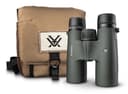 Vortex Triumph HD 10x42 Glass more ground than you can walk The cheapest way to get a Vortex VIP warranty around your neck. The Triumph is Vortex's entry line, and it exists precisely for the hunter who wants the warranty safety net at the lowest possible entry price. | 10x42 · HD | 8.8/ 10 | $99.00View on Amazon Price as of October 20, 2026. #ad How we’re funded |
| 2 | 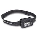 Black Diamond Spot 400 For the dark walk that beats the crowd The headlamp that mountaineers trust, at a price a hunter can justify. Dimmable output matters more than peak brightness in the woods — you want the least light that gets the job done. | AAA · dimmable | 8.9/ 10 | |
| 3 | 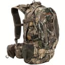 ALPS OutdoorZ Pursuit Pack The pack for scouting days and hunt days The best-balanced budget hunting pack: enough room for a full-day sit and a weekend, a built-in blaze-orange rain cover, and a bow/gun carry system. The one most whitetail hunters should buy. | ~2,700 cu in | 9.0/ 10 | $119.99View on Amazon Price as of October 20, 2026. #ad How we’re funded |
Check your state’s regulations. Hunting laws vary by state and change year to year — legal calibers, minimum bow draw weights, blaze-orange rules, seasons and treestand requirements included. Confirm the rules with your state wildlife agency before you hunt. Blaze & Budget is written by an enthusiast, not a game warden, and nothing here is legal advice.
Frequently asked questions
How do you find public land to hunt near you?
Start with your state wildlife agency's own map of wildlife management areas or public hunting areas - every state publishes one, it is free, and it is authoritative in a way a third-party app is not. Then add the federal layers: national forests, Bureau of Land Management ground in the west, Army Corps of Engineers land around reservoirs, and national wildlife refuges that allow hunting. In most states those four sources cover more ground than you can hunt in a lifetime.
Do you need a paid app like onX to hunt public land?
No, and in a first season the money is better spent elsewhere. Paid mapping apps are genuinely useful - offline maps and private-property boundaries are their real value - but the agency maps are free and authoritative, and free satellite imagery shows you cover and terrain just as well. Buy the app in year two if you find yourself hunting boundary lines you cannot read.
How much public hunting land is there?
More than most new hunters assume, and it is concentrated in state programmes you have to look up by name. Minnesota alone publishes over 1,500 wildlife management areas covering 1.39 million acres open to hunters, and that is one state's system - on top of national forests, BLM land, Corps of Engineers ground and refuges that permit hunting.
How do you find spots other hunters miss?
Walk further than is comfortable, hunt the awkward shapes, and use access that other people avoid. Pressure drops sharply about a mile from a parking area and again on the far side of any obstacle - a creek, a steep face, a swamp, a long walk through open ground in the dark. The best public-land spots are rarely the best habitat; they are decent habitat that is annoying to reach.
Can you hunt national forest land without permission?
Generally yes - national forest land is open to hunting under state law, with a valid state licence, subject to any area-specific restrictions the forest publishes. The US Forest Service's own guidance is that state hunting laws apply and that you must check for local closures and restrictions before you go. Always confirm the specific unit rather than assuming the whole forest is open.
Is walk-in access the same as public land?
No, and the distinction matters. Walk-in access programmes pay private landowners to allow public hunting on their ground during defined seasons, usually on foot only, often with extra rules about vehicles, camping and blinds. It is free to the hunter and it is some of the least pressured ground available - but it is someone's property, and the enrolment can change from year to year.
When should you scout public land?
Late winter is the best time and almost nobody does it. After the season closes, sign is still readable, the cover is down, and you can walk anywhere without worrying about spooking the deer you intend to hunt. Summer scouting from a distance with binoculars is the second-best option, and in-season scouting is the most expensive kind - every trip in is pressure you are adding yourself.
Sources
- Hunting — US Forest Service — USFS rules for hunting on National Forest System land — state-law compliance and area restrictions (accessed July 22, 2026)
- Wildlife Management Areas — Minnesota DNR — A state example of public WMA hunting access: 1,500+ areas, 1.39M acres open to hunters (accessed July 22, 2026)
- Americans Spent $394B on Hunting, Fishing and Wildlife-Associated Activities in '22 — U.S. Fish & Wildlife Service — The 2022 National Survey: 14.4 million Americans hunted, about 6% of residents aged 16 and over, within $394 billion of total wildlife-associated spending (accessed August 19, 2026)
- Learn to Hunt — National Deer Association — National nonprofit beginner pathway — Deer Hunting 101, Field to Fork and mentorship (accessed July 22, 2026)
Keep reading
Public Land Hunting Gear List
Once you have found the ground - the kit that suits hunting somewhere you cannot leave anything.
Read the guidePublic Land Treestand Rules
What you can hang, what you must remove, and the rules that vary by unit.
Read the guideHow to Glass for Deer
The skill that turns a road-accessible viewpoint into real scouting information.
Read the guideDeer Hunting on a Budget
The whole season costed out for a hunter with no lease and no land.
Read the guide